The second trip: Trollstigen ( the Trolls Ladder ) http://goo.gl/maps/cEnAkThe First stop : The viewpoint in the Ørnesvingane
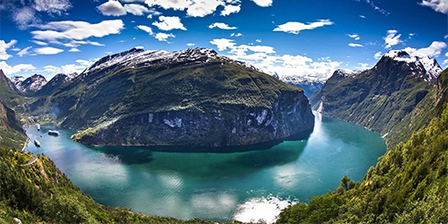
Ørnevegen Eagle Road is the name given to the steepest stretch of road up the mountain side from Geiranger towards Eidsdal on riksveg 63.
The road swings through 11 hairpin bends up from the Geirangerfjord and to the highest point on the stretch, 620 metres above sea level at Korsmyra.
The road was officially opened on 15th September 1955 and gave the village of Geiranger year-round road access.
The road was an attraction from the very first day, and was called Eagle Road because at its highest point it passed through terrain that had traditionally been the domain of a large number of eagles.
The name also reflects the wildness, the spectacular that tourists and others using the road will experience, especially if they stop at Ørnesvingen, the highest of the hairpins. Facilities have been provided here for visitors to take in the magnificent panorama over Geiranger, the Geirangerfjord, the Seven Sisters Falls and the alpine farm Knivsflå, or to gaze down on the many cruise ships that traffic the fjord far below.
The viewpoint has been recently upgraded, and was officially opened on 21st June 2006 with a simple ceremony as part of the project Nasjonal Turistveg (National Tourist Roads) under the auspices of Statens Vegvesen, - The Norwegian Public Roads Administration.
Ørnevegen has a one in ten incline at its steepest, and can test both drivers and vehicles that traffic the road in the winter months. Private and commercial vehicle branch interests use the road as a test bed to improve the road-holding capabilities of vehicles in winter conditions. The longest vehicle length permitted is 15 metres.
The Second stop: Eidsdal ferry port ( Eidsdal Linge) 
This connection cross the Norddalsfjord is 2.7 km and it takes about 10 minutes to cross.
The ferry port on the Eidsdal side of the fjord, is located in the center of Eidsdal village, while Linge ferry port is a little more deserted place just west of the farm Linge in Valldal.
The connection has its own summer schedule with higher frequency to operate tourist traffic to and from Geiranger.
Usually the ferry departs every 15 minutes, but since it's on a Sunday, it may be longer between individual departures.
Prices:
Motorcycle with rider 47 NOK
An adult 28 NOK
Children 14 NOK
Valid payment method is both cash, credit cards and special ferry-cards.
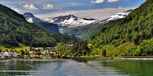
TheThird stop: Viwepoint Dyrkorn/Viset ( Point E. on the map.)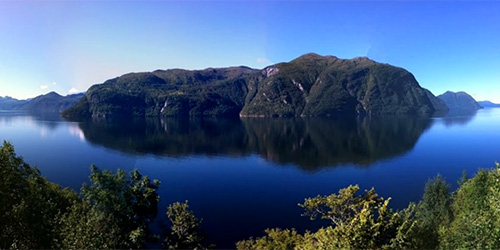
This is a viewpoint above the Storfjorden..
Here the group will split into two groups.Group 1: Those who
want to drive on gravel road.
http://goo.gl/maps/rgDY5 Group 2:
 Those who
dont want to drive on gravel road.
http://goo.gl/maps/7yasV  Group no. 1
, will take the road over Vaksvikfjellet, to the Tresfjord on the other side.
The narrow road over this mountain is 16km long and of which 11.5km is gravel road.
This road has no steep ascent or descent, simple and straightforward gravel drive.
 Group no.2
, will continue on the road 650 to Sjøholt and then take the E136 over the Ørskogfjellet into the Tresfjord where the groups will meet again.
This is a distance of 32km consisting only of asphalt.( Twice as long as the other route, but twice as fast. )
 The Fourth stop: Tressfjorden
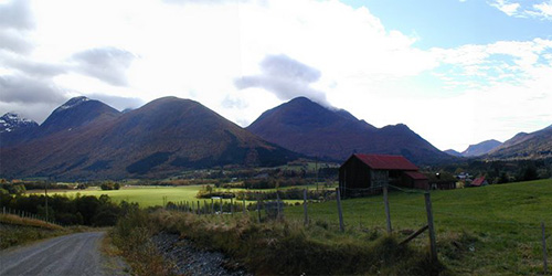
Here, the fastest group will waiting for the slowest, and then drive on together to Åndalsnes.
The Fifth stop: Åndalsnes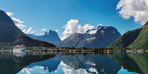
Here we will stop for some lunch and refuel the bikes if necessary.
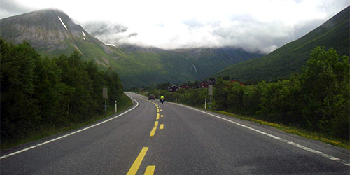
The Sixth stop: At the foot of the Trollstigen
This stop is for those who want to and take photos etc.
I recommend that we drive up the ladder in smaller groups or individually.
This is because the road is narrow and there will be plenty of stopping if larger groups will drive up simultaneously.
The guides will arrange this on-site I think.
The Seventh stop: The top of the Trollstigen 
Trollstigen National Tourist Road officially opened on 16 June 2012. The Trollstigen Mountain Plateau was designed by Reiulf Ramstad Architects AS.
Trollstigen is legendary and attracts a large number of visitors during the few hectic months of summer.
The walkways and steps out to the outlook, invite the traveller to stroll around and experience the mighty landscape.
The largest viewing platform is dramatically located, jutting out over a ridge with a perpendicular drop of approximately 200 metres.
This has different outlook points for those who dare not go out to the furthest point, while those who are bolder can go all the way to the tip of the platform where the railings end in a glass panel.
In 1905 a licence was granted for the building of a horse trail over Stigfjellet, the so-called Kløvstien track.
But even then there were already thoughts of building a road between Valldal and Rauma.
Although many people believed it was utter madness to build a road over Stigfjellet, in 1916 the Norwegian Parliament the Storting gave the go-ahead andt he construction of the road commenced a couple of yearslater.
The building of the mountain pass began in 1928 and was a huge challenge.
The area was steep and prone to landslides, and often there was flooding and bad weather. Because of the long winter, the road construction period only lasted from the middle of May to September/October every year.
The work went smoothly with few accidents, and the navvies showed their artistic skills as stonemasons in their work on the road and bridges.
The new road, which was given the name Trollstigen, was opened on 31 July 1936 by King Haakon.
At the end of the 19th century tourism in the area began to increase.
As a deliberate marketing initiative, the mountains around Trollstigen were given new names such as Kongen (the King), Dronningen (the Queen), Bispen (the Bishop) and Trollveggen (the Troll Wall).
The Knivsflåfossen waterfall in Geiranger was renamed De syv søstre (the Seven Sisters), and the road over Stigfjellet became Trollstigen (the Trolls Ladder).
In 1936, the same year as Trollstigen opened, Trollstigheimen was completed at Alnesreset, the highest point at 852 metres above sea-level.
The restaurant could cater for 180 visitors. However, in 1963 the building was damaged in an avalanche and was not rebuilt.
In 1979 a new restaurant was established at Stigrøra.
In order to maintain the importance of the site as one of the prime tourist attractions in Norway, all the old buildings have been demolished, and the entire area has now emerged with a new and modern appearance.
Once everyone has filled up their cameras and camcorders, we will ones again gather the group and drive over the mountain to the Valldalen and further to Linge ferry port.
The Eighth stop: Linge ferry port. ( Linge Eidsdal ) 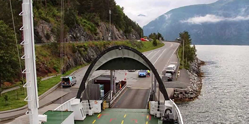
This is the same ferry that we took in the morning. (The other way of course).

And then back to Geiranger.
-----------------------------------------------------------------------------------------------------------------
Well this was roughly the routes.
This is, as I wrote before, not the final routes, but there will be no major changes compared to these.
All potential changes will be made in red so it will be easy to see.
So all we have to do is to hope that the weather is on our side both days, that is no sure thing here on the west coast of Norway.
kjetil --------------

--------------